
Places to Watch Eighth Edition: Five Indicated Illegal Logging Area in Indonesia
The Eighth Edition presents the Top 5 Places to Watch indicated to be illegal logging areas from 1 October - 31 December 2019.
The Places to Watch series utilizes GLAD Alert method and data from Global Forest Watch which is analyzed on a quarterly basis.
#1 Kuala Tolak Village, Matan Hilir Utara Sub-District, Ketapang District, West Kalimantan Province: 591.21 Ha
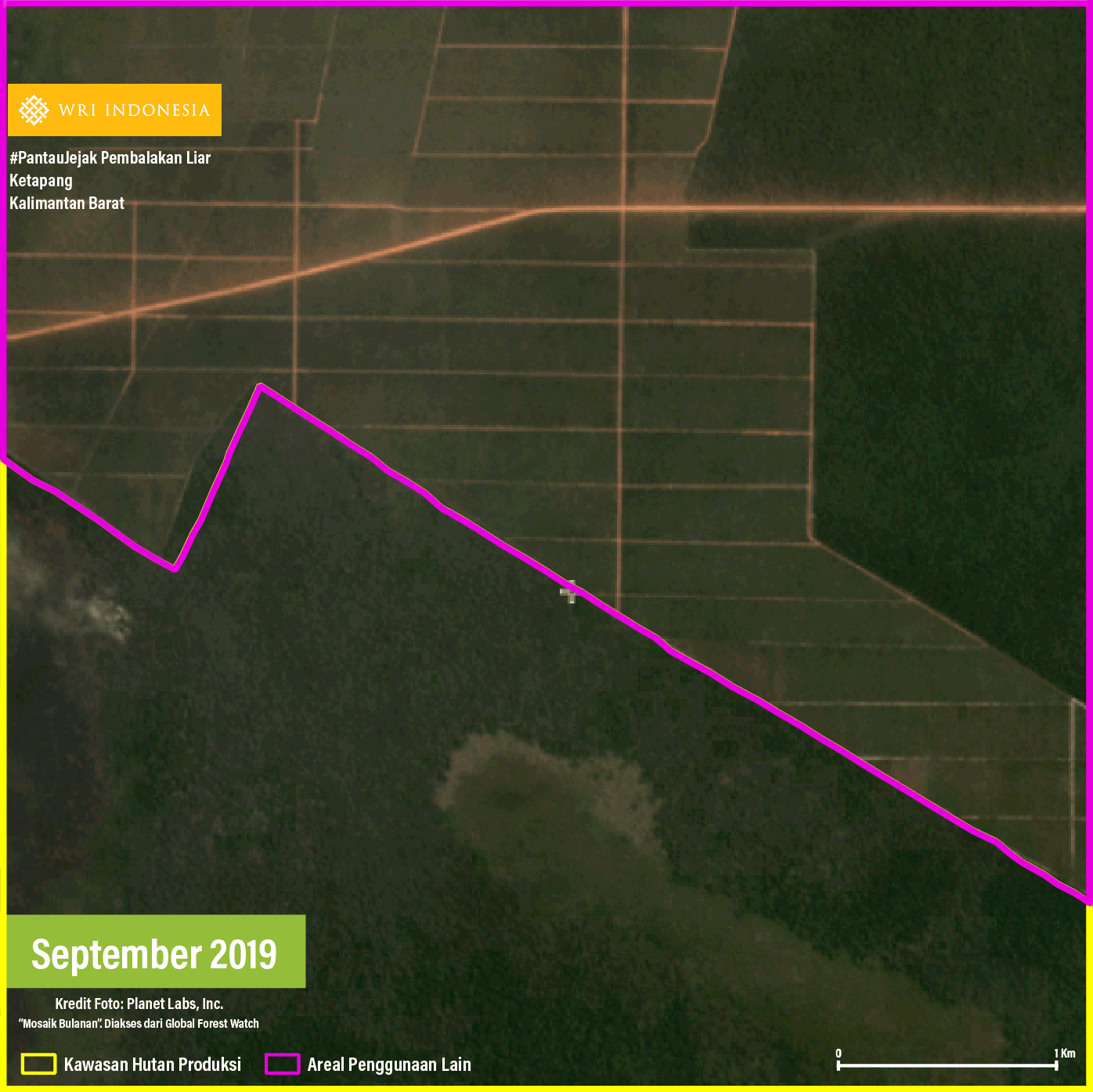
The indicated area #1 is located in a production forest area with secondary swamp forest cover. This area is bordered by large blocks of plants and a road leading to the north, which is indicated as a large plantation area. Observation of high-resolution satellite imagery indicates that logging activities have been carried out for land clearing, followed by land burning from the beginning of September to the end of November 2019. The purpose of land clearing cannot be identified because the land has not been cultivated until the end of the observation period.
Supporting the observations of the satellite imagery, last February, the Quick Response Forest Rangers Unit (SPORC) of the Ministry of Environment and Forestry (MoEF) found illegal processed timber in a sawmill in Kuala Tolak Village. This case has been brought to the West Kalimantan Public Prosecutor.
#2 Palingkau Village, Danau Sembuluh Sub-District, Seruyan District, Central Kalimantan Province: 566.82 Ha
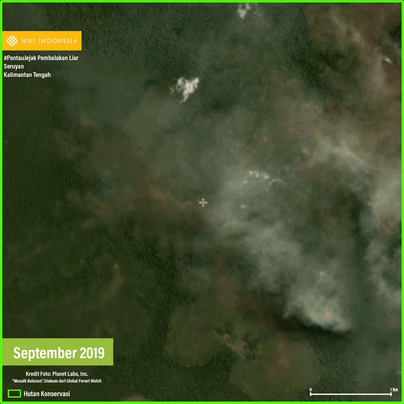
The indicated area #2 is located in Tanjung Puting National Park with secondary swamp forest cover. This area is adjacent to the palm oil concession area, which is located in the west of the indicated area. Observations of high-resolution satellite imagery indicate a pattern of land clearing that has been taking place since September 2019 when fires occurred in the area. The cause of land clearing cannot be identified because the land has not been cultivated until the end of the observation period.
In May 2019, the Save Our Borneo Organization reported that oil palm plantation permit holders cleared land outside their land and encroached the production forest areas around Danau Sembuluh. Although it does not specifically state the name of the village where such practice is carried out, the report provides information about indications of illegal logging in the landscape surrounding Danau Sembuluh.
#3 Sungai Nanjung Village, Matan Hilir Selatan Sub-District, Ketapang District, West Kalimantan Province: 428.67 Ha
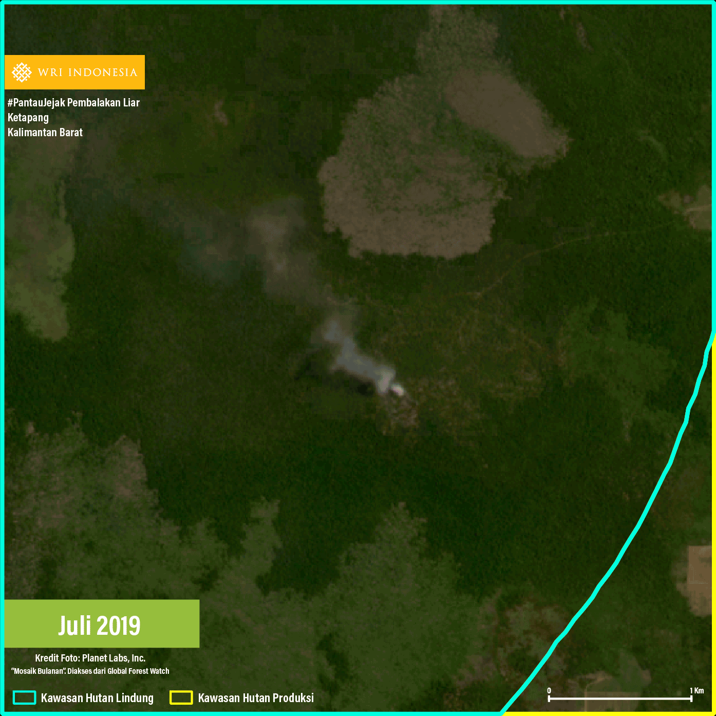
Indications of illegal logging were found in Sungai Nanjung Village, which is part of the West Kalimantan Unit XXXI Production Forest Management Unit (KPHP) with secondary swamp forest cover. Observation of high-resolution satellite imagery reveals that land clearing begins with selective logging, followed by land burning from September to October 2019. The purpose of clearing forests adjacent to a concession area with a Business License for the Utilization of Timber Forest Products – Industrial Plantation Forest (IUPHHK-HTI) cannot be identified because the land has not been cultivated till the end of the observation period.
In early 2020, orangutans reportedly entered the plantation area of the residents of Matan Hilir Selatan Sub-District, Ketapang. This was allegedly caused by the degradation of forests which function as the orangutan habitat due to illegal mining and logging activities.
#4 Rababaka Village, Woja Sub-District, Dompu District, West Nusa Tenggara Province: 370.53 Ha
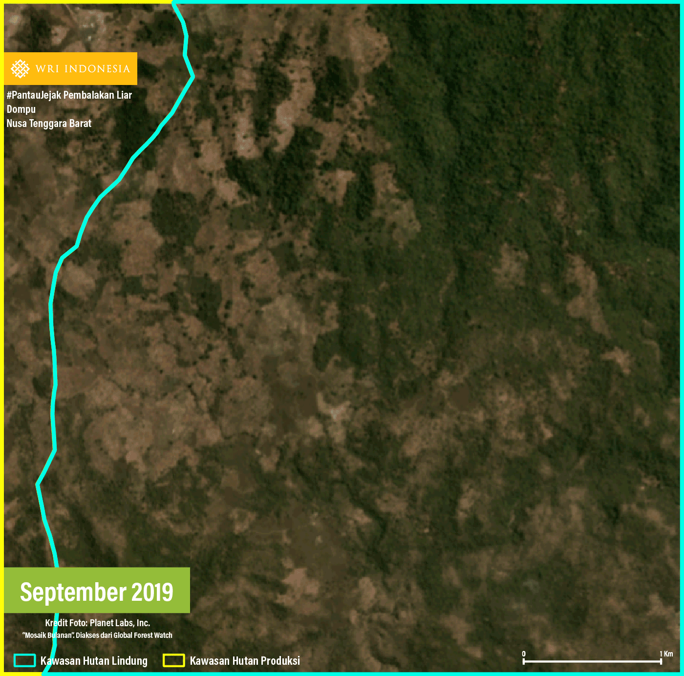
The fourth (#4) indicated area is an expansion of the second (#2) indicated area in Places to Watch Seventh Edition, which is an area of primary dryland forest. This area is adjacent to a concession area with Business License for the Utilization of Timber Forest Products – Industrial Plantation Forest (IUPHHK-HTI) and is also located in the Unit XIX Protected Forest Management Unit (KPHL) of West Nusa Tenggara. Observation of high-resolution satellite imagery indicates land clearing was performed however the purpose remains unknown as the land remains uncultivated till the end of the observation period. In particular, GLAD Alerts detected forest clearance in the southeastern part of the region, but observation of satellite imagery shows no forest clearing in this area, hence the GLAD alerts for this region are considered to be false positives due to seasonal changes during the observation period. False positives are circumstances when alerts detected logging activities in an area, but data checking indicates that no logging activities have been carried out. In October 2019, the urban area of Dompu was reportedly for the first time shrouded in haze due to forest fires, which was believed to be an impact of forest clearing in the agricultural land in Dompu District.
#5 Simpang Gaung Village, Gaung Sub-District, Indragiri Hilir District, Riau Province: 334.89 Ha
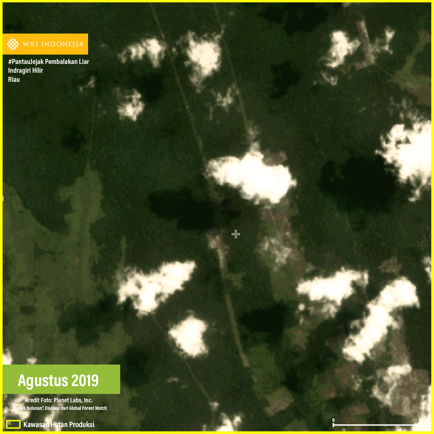
The indicated area #5 is a production forest area with secondary swamp forest cover. This area is adjacent to a concession area with a IUPHHK-HA and IUPHHK-HTI, and is also located in the Unit XXVII Protected Forest Management Unit (KPHL) of Riau. Observation of high-resolution satellite imagery indicates that logging activities have been carried out since September 2019 and continued till November 2019, followed by land burning. The pattern observed is logging for land clearing, but the specific purpose has not yet been identified because the land has not been cultivated till the end of the observation.
In March 2019, a resident was allegedly attacked by a Sumatran Tiger in Simpang Gaung Village. The Natural Resources Conservation Agency (BKSDA) stated that this incident was related to the destruction of Sumatran tiger habitat due to illegal logging. In addition, the Walhi Organization in Riau stated that destruction of the tigers' habitat was a result of logging and forest conversion to plantation and forestry industries in Indragiri Hilir District, particularly in Gaung Sub-District.
The Next Step
These Top 5 Places to Watch are only indicated areas, resulting from observations using several tools, namely GLAD Alerts, Forest Area Status Map and Land Cover/Utilization Map. However, this analysis can be used in determining the areas where monitoring for illegal logging must be prioritized. Thus, subsequent steps that must soon be implemented are as follows.
1. Field Verification and Responsive Actions to Prevent Expansion of Illegal Logging in the Five Indicated Areas.
Indicated area #4 show that the forest clearing activities are continuation/expansion of existing activities in indicated area #2 in the Places to Watch Seventh Edition. This area requires special attention because of the high risk that continuous illegal logging which can extend to the surrounding forest area. In addition, the five Indicated Areas also indicate the urgency of mitigating environmental damage because four areas are swamps, one area is located in a conservation area, and environmental disasters have occurred in areas surrounding the indicated area, such as forest fires and conflicts between wildlife with humans.
Therefore, the institutions authorized to protect the forest areas within the five indicated areas, such as relevant Forest Management Unit, Natural Resources Conservation Center (BKSDA), the Director General of the Ministry of Environment and Forestry, the Provincial Forestry Office and the local police, must collaboratively conduct a field verification and take responsive actions to prevent further expansion of illegal logging and utilization of forest area as soon as possible. Local community participation by providing field information can also strengthen the verification process. If the field verification is not carried out immediately, illegal loggings will be increasingly massive and the negative impacts from environmental degradation are imminent. The wider the forest area that has been cleared and utilized for non-forestry activities, the more difficult the mitigation and recovery efforts.
2. Following Field Verification, Responsive Actions Must Take into Consideration Socio-Economic Aspects of the Local Communities.
Illegal logging activities across the Five Indicated Areas are all closely associated with small-scale economic activities. Therefore, following the field verification, responsive actions must take into consideration socio-economic aspects of the local communities. The mechanism may include a fair scheme of conflict resolution, social forestry, agrarian reform, and law enforcement. It is also necessary to trace the suspects of the illegal logging up to the mastermind (intellectual actors) who take advantage of the illegal logging activities.