
Places to Watch Tenth Edition: Five Indicated Illegal Logging Area in Indonesia
This tenth edition features the top 5 Places to Watch for indications of illegal logging between 1 April and 30 June 2020. Places to Watch uses the method and data of GLAD Alert from Global Forest Watch, which is analyzed quarterly.
#1 Upang Marga Village, Air Salek District, Banyuasin Regency, South Sumatra: 97.47 ha
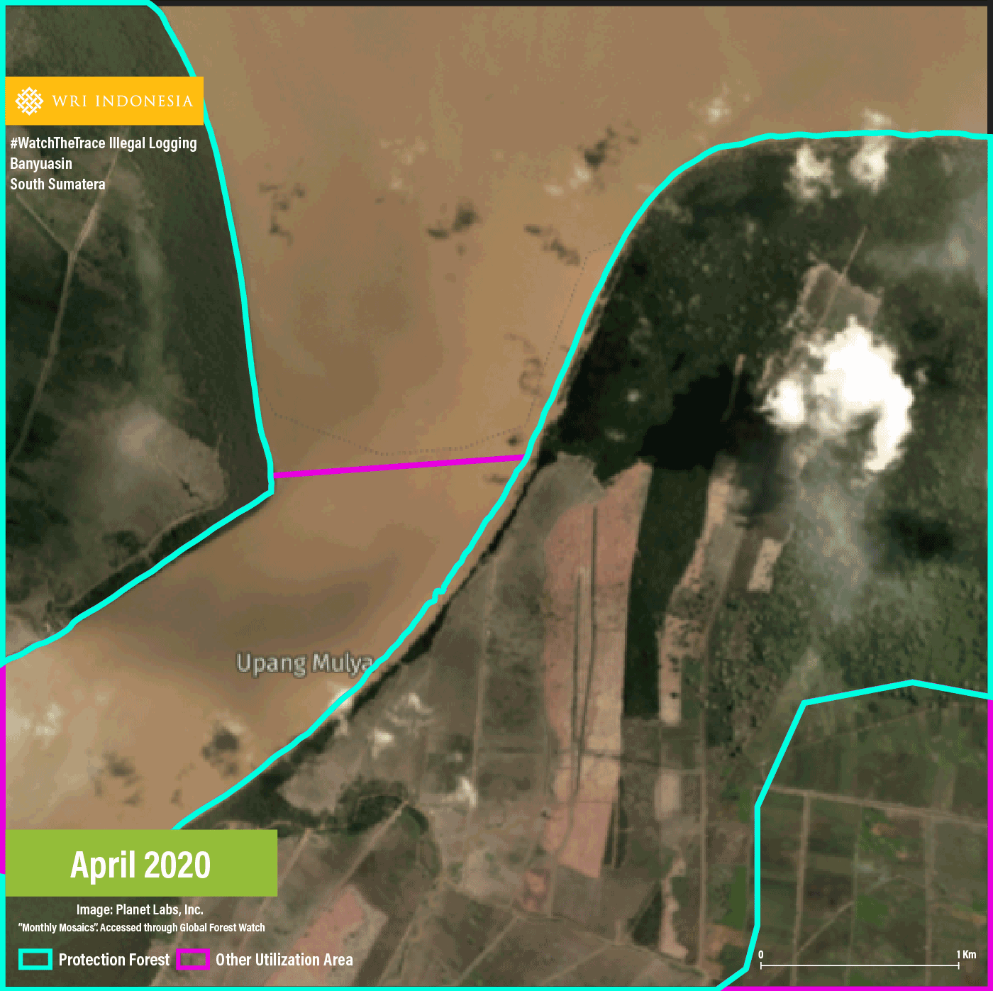
Indicated area #1 is located in an area belonging to a Technical Implementation Unit of the Protected Forest Management Unit (UPTD KPHL) for Area III Palembang-Banyuasin with secondary mangrove forest cover. The clearing is visible as orderly blocks in sizeable area. The area directly borders with an area of other use (APL) to the south with a palm oil plantation cover. This area has been identified in previous Places to Watch editions as indicated area #3 in edition 6, indicated area #3 in edition 5 and indicated area #5 in edition 3. Satellite image shows that the indicated areas both in this edition and previous editions remained unplanted by the end of the observation period.
This is the fifth mention of Banyuasin Regency in Places to Watch. A news coverage in 2018 reported that illegal logging in South Sumatra has been ongoing since the 90s and Musi Banyuasin Regency is one of the areas most effected where rampant illegal logging has been reported in protected forest areas. According to reports, illegal logging in South Sumatra also increased in 2020.
#2 Loka Village, Tolala District, North Kolaka Regency, Southeast Sulawesi Province: 58.41 ha
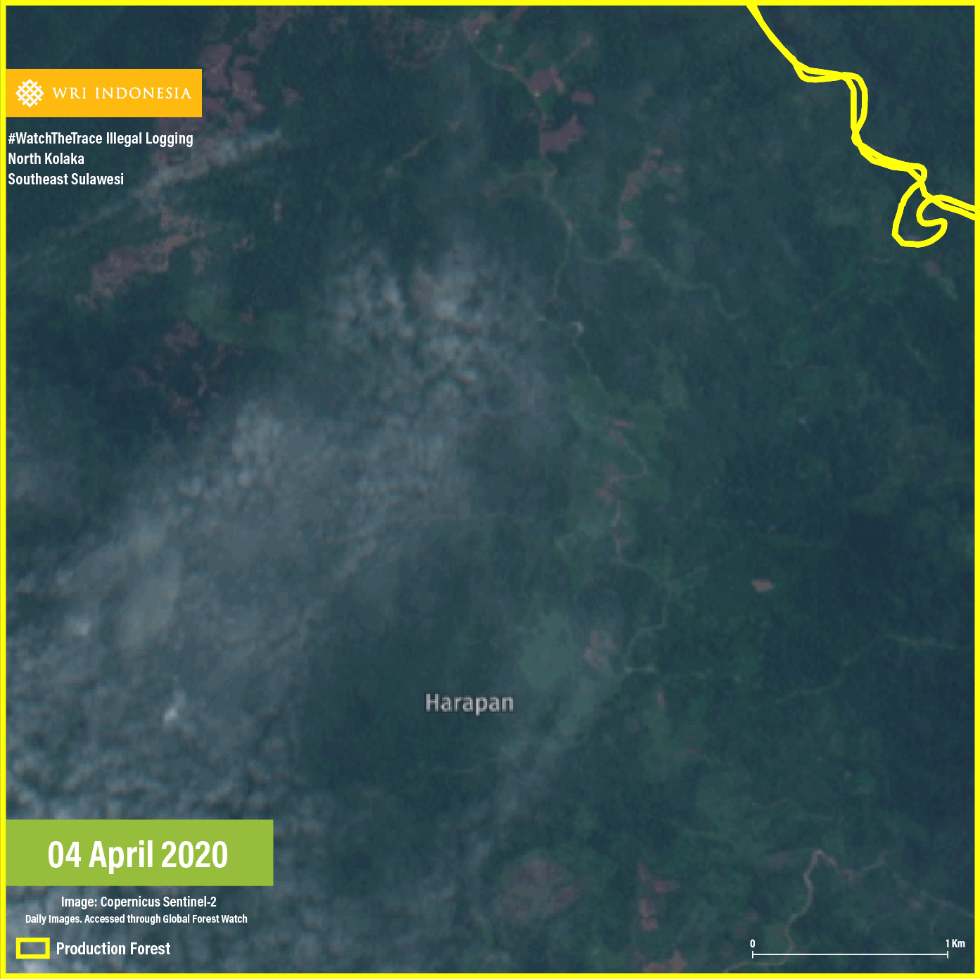
Illegal logging is indicated in North Patampanua Production Forest Management Unit (KPHP) XVII with secondary dryland forest cover. According to satellite image, the forest clearing area is located on the side of a logging road and the clearing has been ongoing since March 2020. Many logging roads are observed around this area, while the land-clearing pattern indicates new forest clearing. The reason for the forest clearing has not been identified because the cleared area hadn’t been utilized by the end of the observation period. According to reports by Kendari Pos, Loka Village and Tolala District are seeing sizeable land clearing in forest areas. Land clearing for non-forestry activities has been alleged to be the cause for the 2018 flash flood in North Kolaka Regency.
#3 Usar Village, Plampang District, Sumbawa Regency, West Nusa Tenggara: 38.65 ha
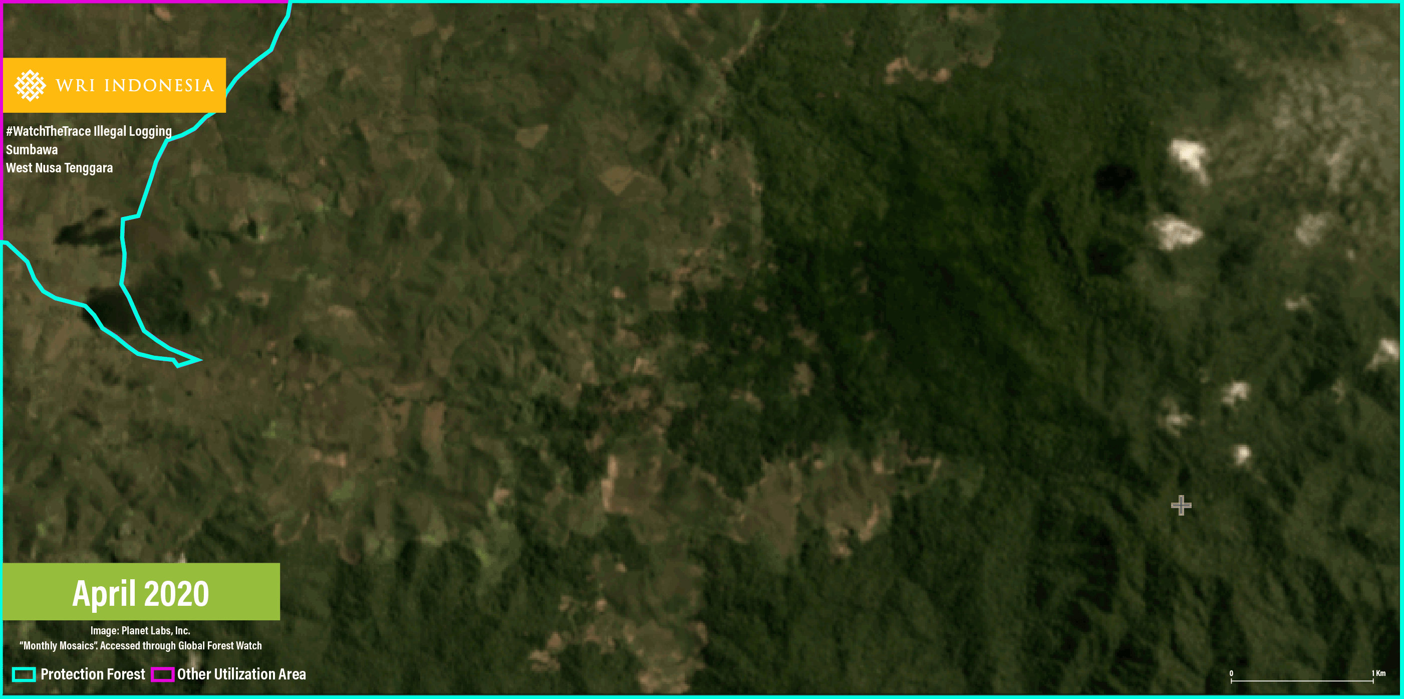
Indicated area #3 is located in an area belonging to Ampang Plampang Protected Forest Management Unit (KPHL) XIV with secondary dryland forest cover. Satellite image shows sporadic small areas of land clearing. Since East Nusa Tenggara is extremely dry, such forest clearing pattern may be perceived to indicate dryland farming in some seasons and shrubland in others. By the end of the observation period, no planting activity had been observed on the logged-over land.
According to Mongabay, Plampang has become prone to flood as illegal forest logging and forest encroachment continue in West Nusa Tenggara, mainly driven by cornfield expansion as one of the region’s main commodities. According to the Chairman of Ampang Plampang KPH, forest encroachment for cornfield has been ongoing since 2012-2013.
#4 Tembalang Village, Tulin Onsoi District, Nunukan Regency, North Kalimantan: 34.74 ha
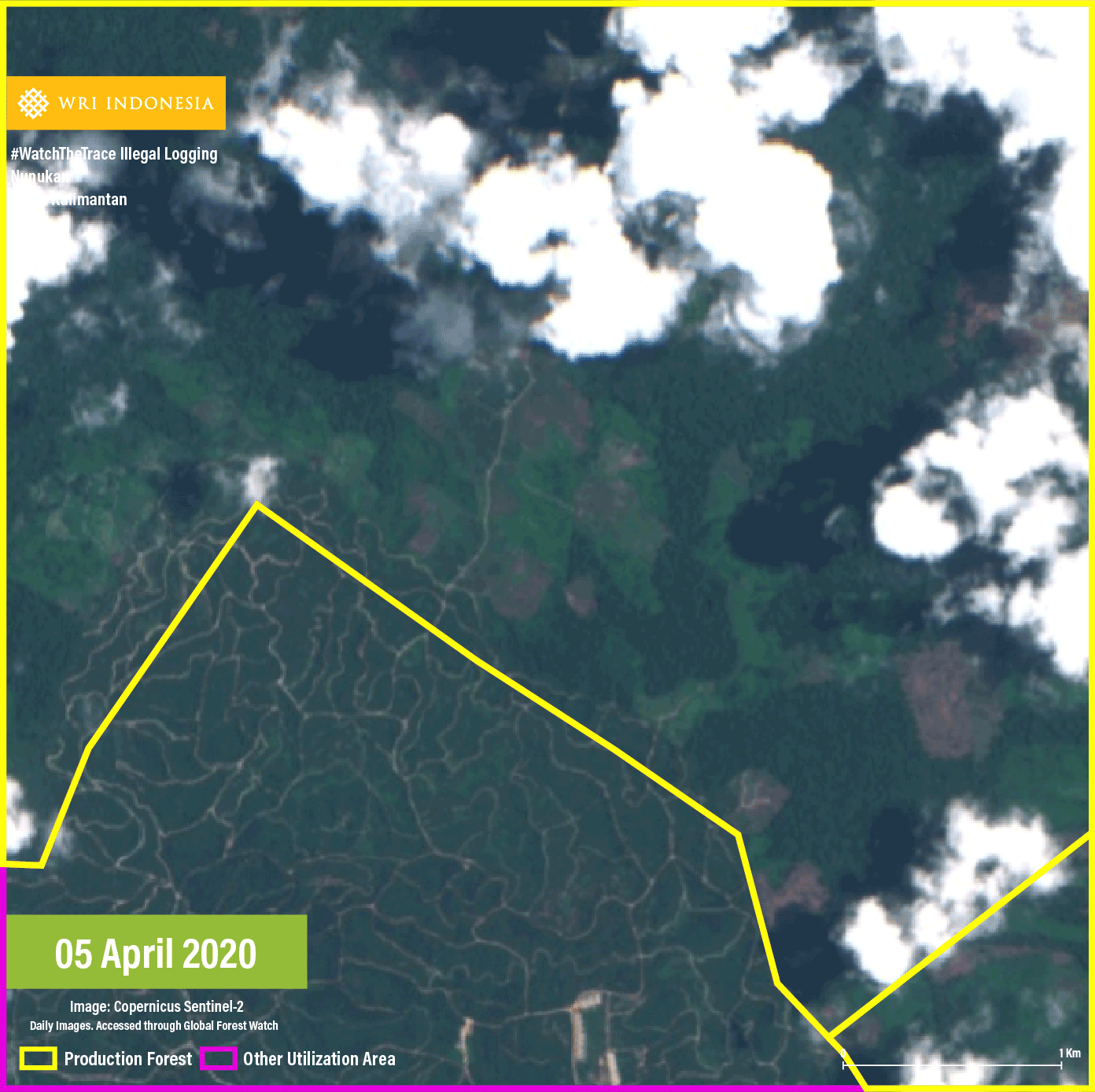
Indicated area #4 is located in Nunukan Production Forest Management Unit (KPHP) IV with secondary mangrove forest cover. The logged-over area borders with an IUPHHK-HTI concession to the southeast and a palm oil concession to the southwest. Satellite image shows sporadic medium-sized areas of clearing, an extension of previous forest clearing. Designation of the cleared forest has not been identified since the area remained unutilized by the end of the observation period.
KPHP Nunukan IV was also displayed as indicated area #4 in Places to Watch ninth edition. Several illegal forest logging incidents have been reported in Nunukan Regency. In late June 2020, for example, the media reported the finding of wood piles, allegedly from illegal logging.
#5 Engkitan Village, Central Ketungau Disrict, Sintang Regency, West Kalimantan: 30.69 ha
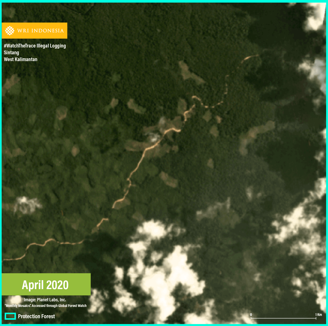
Indicated area #5 is located in KPHL North Sintang with a primary dryland forest cover. Small logged-over areas are spread on the side of an alleged logging road. This area directly borders with a small-scale monoculture plantation. The designation of the logged-over forest however, hasn’t been clearly determined, as no planting had been done by the end of the observation area.
Land use in Sintang Regency is facing a lot of spatial issues. Fifty-four (54) villages have been reported to be located in a protected forest. Central Ketungau District is one of the districts reported to face major development issues due to forest area status, including pertaining to plantation and agriculture.
The Next Step
The Five Places to Watch are identified based on indications analyzed using various instruments such as GLAD Alert, Forest Area Status Map and Land Cover/Utilization Map. However, this analysis can be used in determining the areas where monitoring for illegal logging must be prioritized. To that end, the following steps need to be taken immediately.
1. Field Verification and Action to Prevent Expansion of Illegal Logging in the Five Indicated Areas.
Field verification must be done in these five Indicated Areas as a follow up. In this edition, indicated area #1 needs to be a focus due to its location in a protected forest as an extension of a previous clearing recorded in Places to Watch three editions back. This is also the fifth mention of Banyuasin Regency as five places to watch for illegal logging. This indicates that more commitment to observing the landscape management pattern in Banyuasin Regency is needed.
As such, authorities in charge of forest protection at the five indicated areas such as the relevant Forest Management Units (KPH), Directorate General of Law Enforcement under the Ministry of Environment and Forestry, the local Province Forest Service and the local Police must collaborate to conduct field verification and take preventive measures to prevent further illegal logging and illegal forest utilization.
Community participation in providing information from the field may help in the verification process. If field verification is not conducted promptly, illegal logging will grow massively and the negative environmental impact will be inevitable. As the forest area that has been cleared and utilized for non-forestry activities grows larger, its management and restoration will become more challenging.
2. Upon Verification, the Handling Process Must Take Into Account Socio-economic Background of Local Communities.
Illegal logging across the five Indicated Areas is closely associated with small-scale economic activities. As such, upon verification, the handling process must take into account the socio-economic background of the local communities. The handling mechanism may include logical and fair conflict resolution, social forestry, agrarian reformation and fair law enforcement schemes. In addition, it is also necessary to trace the perpetrators back to the masterminds (intellectual players and funders) who are reaping the ultimate benefits of illegal logging.